The morning is cool, crisp with light broken clouds...looks like a perfect morning to head up the mountain...by RV, of course.
We get an early start, and head out on the hour-long drive to Sunrise on the northeastern side of Mount Rainier National Park. Sunrise is one of two major visitor centers (the other is Paradise on the south side of the mountain) and is a major jumping-off point (figuratively speaking) for many great hikes. One of our favorites is the Burroughs hike...there is an undulating ridge that comes off the mountain to the east/southeast and there are three crests along the way, each called Burroughs...First Burroughs, Second Burroughs, and Third Burroughs. We've hiked First and Second in the past and they give you views of the mountain that are unreal...like you could reach out and touch it. We want to try Burroughs today, but the ranger at the Ohanapecosh Visitors Center said that they are not recommending it due to the ice and snow that still remains on the trail. So, we'll make a final decision when we get to Sunrise, but we'd really like to hike Burroughs...
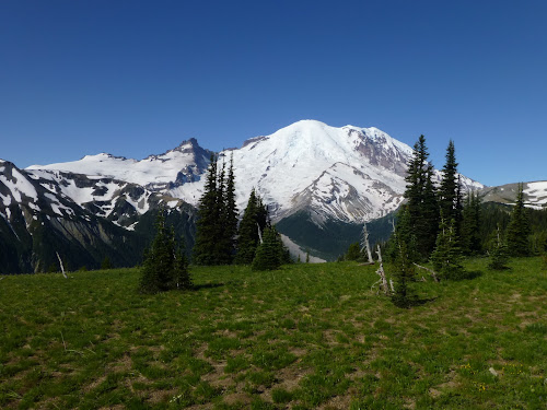
It is early, so we get those great, crisp, clear views of Mount Rainier as we approach Sunrise...
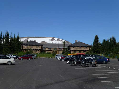
Sunrise, our starting point today, has a large parking lot to accommodate day and overnight hikers, as well as a lodge with a snack bar and a visitors center. Because we're early, the lot is not full at all...later in the day this lot will be completely filled. We get geared up, and hit the trail...
There is no shortage of breathtaking views...even as we climb up the trail out of Sunrise we are greeted with views of Mount Rainier to the west and the valley off to the south...
At the first viewpoint on the trail, we get a view to the north, and if you zoom in you can see the cascade mountains in the distance poking up through the clouds...
Just like we saw on the Crystal Lakes hike two days ago, flowers are blooming and the hill sides nearby are green...
There is still alot of snow on the ridges across from our trail..we wonder if it will melt out before the first snowfall which could be in a couple of months...!
Even as we make our way toward the trail intersection with the Burroughs Trail, we encounter snow...and we're really not that high up the mountain...!
We reach the decision point and we decide to try Burroughs...it looks pretty dry from here. We pass a threesome of hikers and they say that there is ice and snow across the trail so they turned back. We, being the intrepid (and perhaps a little hard-headed) hikers that we are, think that we can probably conquer any ice or snow we encounter...so upward and onward!
This particular trail takes us through a unique area of tundra, and the signs indicate that it is a fragile area so everyone should stay on the trail.
Awwwww, they're probably just being extremely cautious and conservative...or maybe that was put here last week but the snow is almost gone by now...so, without any ice axes (or trekking poles for that matter) we continue on. We can do this...!
Hmmm, now that looks like a bit of tricky trail...ice and snow across a trail that is not only uphill but also side-hill...maybe if we take it slow we can make it across...let's give it a try...
Well, about halfway across the ice and snow patch, trying to dig our boots in to get some secure footing, and trying not to look down and think about the 75 yard slide to jagged rocks that lies to our right, we realize that this might not have been the smartest call. But we have to go all the way to the other side, there is no place to turn around! So we make it slowly to the other side and see the next snow and ice field ahead...which is bigger and surely more risky. The wise decision is to go back down and come back later in the season when the snow and ice are completely gone...we don't like to turn back, but we do.
On the way down we get a great view of Frozen Lake which is at the intersection of several trails in this area of the mountain, and where we will pick up our Plan B trail...Fremont Lookout.
At the bottom of the Burroughs Trail we intersect with the Fremont Trail and off we go...it's a bit of a rocky and dusty trail, but with all the snow around there are very few choices right now.
The bottom section of the Fremont Trail has some vegetation...and flowers are blooming here too...
As we climb the ridge toward the lookout, we look back across at the Burroughs Trail that we tried just an hour ago...and we can see the ice and snow fields that conspired against us...
More flowers greet us as we continue on, and then we encounter the rocky slide areas of the trail that will continue on until we reach the top.
This is a view of the trail and the Fremont Lookout at the end...there's not much growing here on this rocky, gravel ridge, but we're not in it for the trail...we're in it for the views that we will get from the lookout...
We get a sense for the views that lie ahead even as we wind our way along the side of this ridge...the day could not be more perfect for viewing Mount Rainier.
We reach the top..and the hike through dust and rock is worth it...we are afforded a wonderful view of Mount Rainier in all of its snow-capped glory...
To the right is a spectacular view of one of our favorite places on Mount Rainier...it is called Grand Park, and it is a gigantic flat spot on the side of the mountain that at this time of year is a beautiful meadow ringed by evergreen trees...
We enjoy our lunch taking in the nearly 360 degrees of views, and we check out the Lookout...
The lookout is part of a system of forest fire lookouts, and during forest fires (or forest fire season) rangers will climb up here and stay for several days looking for any signs of fires started by lightening or by man.
After lunch, we climb back down to Frozen Lake and then on to Sunrise, and we just can't help ourselves...we take more pictures of Mount Rainier looking gorgeous...
Frozen Lake...this time from the Fremont side!
More great views...
At the main trail in Sunrise, there are signs all over the place reminding folks not to stray off the paths...doing so can ruin an area of very fragile plants that are easily destroyed and will not grow back.
We drive back to our campground, get cleaned up and have our cocktails and dinner. Tonight there is a presentation by a park ranger on the history of Ohanapecosh and we've decided to check it out. The Ohanapecosh campground has a large amphitheater in which presentations are held, and there's a pretty good crowd here tonight.
The amphitheater has benches arranged in a semi-circle around a raised stage with a screen in the middle. It is pretty cool to be sitting and watching a presentation under and among the towering trees...
The presentation turns out to be about five minutes of tomorrow's weather forecast and tips on how to be "Bear Aware" followed by five minutes of history that could be gained from the signs on the Hot Springs trail, and then ramblings about why people enjoy camping at Ohanapecosh so much....we're not sure how long this last part went on, we got up and left after about fifteen minutes...
This is our last night at Ohanapecosh, our last night of this road trip, and our last trip of this amazing three month sabbatical. It has been an amazing combination of experiences, and it will be good to get home and hang out for a couple of weeks before the sabbatical ends.


No comments:
Post a Comment