July 19, 2012
A special part of our first day at Crater Lake National Park is the boat tour on the lake. The day looks like a perfect day for a cruise...sunny, not too cold...and we're anxious to see the rim from the inside.
About the cruise...here's a few details. You can book in advance over the phone or 24 hours in advance at the park. There are two cruises, one that takes you around the lake on a two-hour cruise, and one that takes you to Wizard Island (two boats go to the island, one at 9:30 and one at 12:30) where you have three hours to walk around and then get picked up to complete the lake tour. We chose the two-hour lake tour so that we had the rest of the day to explore the Rim Road. We are expected to check in at the trailhead at Cleetwood Cove at least 45 minutes ahead of our cruise, and we show up about an hour early.
There's a sign at the trailhead explaining that the trail is 1.1 miles long and drops 700 feet from the rim road level to the lake level.
We head down the trail which is mostly in the trees, and from the top of the trail we can see the cruise boat heading out with the first batch of guests going to Wizard Island.
Along the path there are many benches with great views...not necessarily for the hike down to the boat dock, but much more useful on the ascent back from the boat to your car!
The trail has several switchbacks at the top, and then a long straight descending path in the middle portion...and there are more great views as we make our way down to the lake...
We can see both tour boats now...one going to Wizard Island and the other on its counter-clockwise tour circuit of the lake.
The path traverses the inside of the rim of the caldera, which is generally unstable...therefore, we see signs that rocks tumbling down from above is not unusual...
As we get farther down the trail we get a view of the boat dock from which the cruise boats depart...
When we reach the lake, we take a look around and take a few photos, including a panorama from the perspective of lake level at Cleetwood Cove...
This is interesting...this is the official hut in which the equipment is housed that monitors the level of the lake...
This is the boat dock facility...every person assigned to a cruise is given a number, and you have to sign in again at the boat dock with your assigned number so that the park staff know that you have made it down the hill successfully.

Now that we're at the boat dock, looking across the lake and waiting for our tour to begin, let's take a moment to learn about Crater Lake. First of all, Crater Lake is not really a crater...it is a caldera...a caldera is the hole left behind after a volcano collapses in the middle. Mount Mazama was once a 12,000 foot tall mountain, and it went through a series of explosions, the last of which not only blew alot of pumice and earth all around the area, but the last explosion also emptied the chamber of magma beneath the mountain. When the chamber was empty it collapsed and that's how the deep depression (2,000 feet deep) was created. Here's the really amazing part...according to scientists the final eruption that blew ash and pumice debris all over Oregon, Washington, Idaho and Montana, and the collapse of the center of the mountain, only took about 8-12 hours.
After the large eruption, small eruptions continued, and that's where Wizard Island came from...it is a cinder cone (remember the cinder cone at Craters of the Moon, and Red Cone as we entered Crater Lake National Park?), and under the water there are a couple more we can't see.
Now, about the name of the lake...it is actually called Crater Lake not because of the crater-like caldera that holds it...it is actually named after the small crater that sits at the top of Wizard Island!
Over the last 8,000 years, the caldera has collected the rain and snow and has filled to its current (and relatively constant) depth of over 1,900 feet. The water in Crater Lake is the purest lake water in the world due to the source of the water (only rain and snow), and the altitude (and therefore the temperature) of the water. The water clarity is tested regularly by using what is called a Secchi Disk (a black and white disk on a wire that is lowered into the lake), and the disk is typically visible at a depth of more than 100 feet! What's interesting is that major rainstorms can degrade the clarity of the lake and it may take a year or more for the clarity to return...
The waters of Crater Lake are known for their amazing azure color...why is it such a breathtaking blue? Well, because the water is so pure and deep, the sunlight is able to penetrate deep into the water...and when this happens all of the other colors of light are absorbed, and only the blue spectrum gets scattered...thus creating the amazing shades of blue we see...
OK, enough education for the moment, it's time to board the cruise boat and head out on the lake! The cruise boat holds up to 37 passengers...

Our cruise is guided by Ranger Dave, and the boat is piloted by Captain Chris...Ranger Dave is a retired high school teacher from Carson City, Nevada, who has been a seasonal ranger at Crater Lake for the past seven years, and he has a great sense of humor...So we set sail!
We travel in a counter-clockwise direction around the lake, and the first major landmark we see is Devil's Backbone. This dark stone formation is a 2,000 foot wall that is 50 feet wide...it rises as high above us as the lake is deep beneath us...
Llao Rock is a very prominent formation on the northwest side of the caldera, and is named after the Klamath people's chief spirit of the lake.
From our vantage point on the lake, we really get the sense of both the sharp rock formations that were once lava flows, and the pumice slopes that look like they are still sliding into the lake...The next major formation is called Watchman, a large slab of volcanic rock that reaches to 8,000 feet elevation. At the very top there is a watchtower that dates from the early 1930's.
In some places, trees and shrubs have taken root and put some green along the otherwise brown and gray rocky slopes...
On the cruise boat we pass through Skell Channel, the narrow passage between the caldera wall and Wizard Island. The passage is named for the god of the sky in the tradition of the Klamath native Americans.
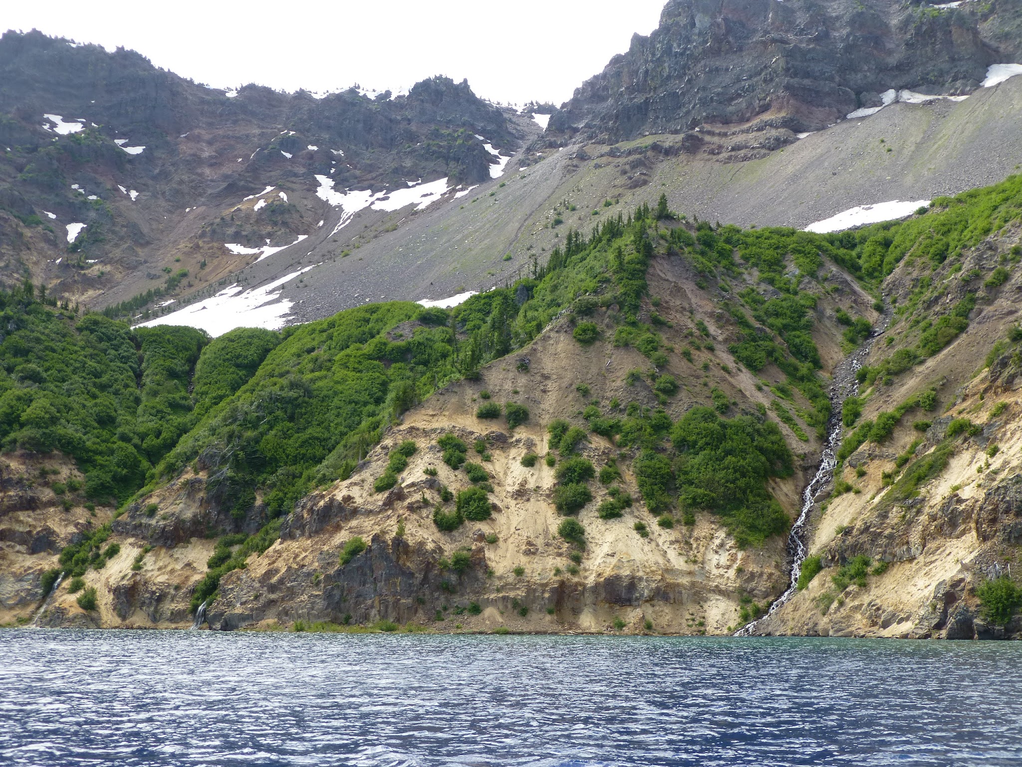
As we continue around the lake, we pass by the stretch of the rim where the Crater Lake Lodge sits...and we enter Chaski Bay. What's noteworthy about Chaski Bay is that it is a portion of the caldera wall that slid after the eruption...and you can see it from a distance, there is a ledge about halfway down the caldera wall which used to be part of the rim. The ledge creates resting places for snow, and therefore we get to see a couple of waterfalls where the melting snow makes its way into the lake...


Next, at the eastern end of Chaski Bay, is the Phantom Ship...an amazing rock formation that juts up out of the lake. It is called Phantom Ship not just because it looks a bit like something out of Pirates of the Caribbean, but also because it can be difficult to see depending on the sunlight and clouds. (Speaking of sunlight and clouds, the wind has picked up significantly, and dark clouds are coming over the south rim as we circle Phantom Ship...you can see that Ranger Dave has donned his coat and his life vest...!). This rock formation is likely the remnant of a lava fissure, and it is nearly 500 feet long, 200 feet wide, and approximately 170 feet tall, and we get to circle it to see it from all sides...Interesting little factoid: every species of tree that is in Crater Lake National Park is also growing on this little rock in the lake...pretty amazing, huh?


We keep one eye on the sky as a storm bears down on us...and we keep the other eye on the amazing sights on the east side of the caldera. This orange rock formation is called Pumice Castle...because it looks like a castle perched high up on the wall of the caldera. It is orange due to the minerals that are in the pumice, so it stands out against the beige pumice that surrounds it...
Now, we just had to take a picture of this rock formation that Ranger Dave pointed out. Look closely at the bottom of the "V" shaped rock, and you may see a face. There was a little debate on our boat regarding who the rock face most resembled...Michael thought it looked like a chimpanzee, Patty thought it looked like Ronald Reagan (who, coincidentally, co-starred with a chimpanzee...).
After a brief windy shower, the skies clear and the sun comes out again...
Now, this portion of the caldera wall is really important. It is called the Palisades, and it looks like a side-by-side craggy vertical columns of dark gray rock. What is so important about this section of the caldera wall is that this is the one area that allows water to seep out of the lake. About 17 billion gallons of water seep out below this rock formation, and that helps keep Crater Lake from emptying altogether...you see, in most volcano calderas that fill with water, the water overruns a section of the rim and collapses the wall or erodes it until the caldera holds little or no water. This unique formation makes Crater Lake possible...
The wind continues, and this look across the lake to the south shows the whitecaps that are being whipped up by the winds..
As we wait for the cruise boat the dock to depart so that we can pull in, Ranger Dave answers our questions, with his usual humor...referring to the staff botanists Drs. Rhoda Dendron and Doug Fir...and the park historian Dr. Eva Destruction.... We also get a view of the trail that we have to climb back up to the rim...
As we return to the top of the rim and the trailhead, we get a great view of the lake with the bright yellow pine pollen on the surface...we're looking all the way across at where the Crater Lake Lodge is perched in the edge of the caldera wall just to the right of center, and then the two peaks of Garfield and Applegate, and then the saddle of Sun Notch...
We could not resist a close-up of Sun Notch...the saddle created by a glacier that is the big dip in the rim compared to all the other peaks...
The boat cruise was terrific (even with the rain and wind squall that came upon us so quickly), and Ranger Dave was entertaining and informative. Seeing the caldera from the inside was fascinating, it really helped us to see the characteristics of the eruptions that created this magnificent lake.
Once we arrive at the trailhead, we hop back in the Roadtrek and get back on Rim Drive in search of a great lunch spot (which is pictured in our Crater Lake Day One: Around the Rim post...check it out!).